

Diamond Maps is a simple cloud-based GIS/Mapping application designed to help municipalies and rural utilities map their sewer and water infrastructure and track maintenance.
"With Diamond Maps we were able to send a guy out on his 3rd day with a list of shut offs. When I started here it was a year before I could do that." - Larry T, West Hardin WSC TX
"I showed my map to the council last night, they all were very impressed." - Jamie T, Greenwood WI
"This software has been exactly what I’ve been looking for, at an extremely low price. Thank you!" David C, Dorris CA
"Invaluable! The best tool out there for any size system period" - Randall W, Sunny Hills FL
"I really like what I see." - Don C, Illinois Rural Water Assoc IL
"This is exactly what I've been looking for." - Randy P, Caddo Co RWD#3, OK
"I use Diamond Maps several times daily. I especially love the GPS feature." - Jeff M , PWSD #1 Dekalb County MO
"To say we are in love with Diamond Maps is an understatement. We are finding new ways every day to use the program. Great job – keep it up!" Michelle H, Midwest Water Group, Chicago
"You have constructed an excellent tool" Jamie H, New York Rural Water Assoc NY
"Why hasn't someone done this before" - Joe J,Coryell City TX
"I have been looking for this for three years" - Randy T,Lake Sara IL
"It is user friendly and as handy as the pocket in my shirt. And that is exactly where I keep my copy of Diamond Maps." Frank O, Platte MO
"This program is super addictive. Do not give to kids that like maps or colors or dots." Jesse H, Olathe KS
"Loving Diamond Maps!" Josh L, East Grand Forks MN
"I was an advocate for this because it requires no training. They just watch the videos." Mike A, People Service, Omaha NE
"The office staff are beside themselves over this map we have created. They've wanted something like this for 25 years" Matt F, Creek Co Rural Water, OK
"The whole crew absolutely loves the app. we are finally getting out of the 1970's index cards" Charlie C, Baudette MN
"BTW... Your mapping system is awesome. Exactly what water and sewer companies need." Nick M, Millersburg PA
"Spectacular mapping system! Even my low-tech guys are using this." Jamie T, Russell Co RWD 3 KS
| General | ||
 | Devices | View or edit your map on any computer, phone, or tablet. Works on Windows, Android, and Apple devices. |
| Online or Offline | Main application is browser based and requires an internet connection. But a free offline app is available for Android devices.video |
| Users | Create seperate logins for each person on your staff. Each login can be used on any phone, tablet, or computer. video |
| Permissions | Control which users can make changes to which layers. video |
| Live Data | All of your users share live access to the map so when one person makes a change, that change appears on everyone else's map. |
| Support | Phone, email, and chat support is included with all subscriptions. |
| Editing | ||
| Draw | Draw points, lines, or areas. video |
| Change | Click on any asset to change it's size, material, condition or other attributes. |
| Adjust | Click and drag to adjust the location of points, lines and areas. video |
| Snap | Automatic snapping of lines and points helps keep your map connected. |
| Batch Operations | Draw a rectangle or fence on the map to select multiple features to delete, move, or assign attributes to. video |
| GPS | Interface Diamond Maps with any Bluetooth capable GPS/GNSS device to mark points precisely. Records position, time, accuracy, and elevation. Offline app records additional GPS metadata. more |
| Excel | For advanced editing export to CSV, edit in excel, and merge data back into layer. video |
| Data Management | ||
| Import | Import from SHP, KML, KMZ, CSV, GPX, Delorme, or Geodatabase. Or just send us your files and our customer support team will import your data for you. video |
| Export | Export to SHP, KMZ, CSV, or Geodatabase. |
| WFS | Built in WFS server allows 3rd parties (with your permission) to connect to Diamond Maps and view your data directly. This might include your county or city's GIS department or your 811 service provider. |
| Background Imagery | Google Maps imagery is used as your base map by default but if you have your own ortho-photography we can add it to your map. |
| Street View | Google street view is available in some areas which allows you to see pictures taken from the street. |
| Contours | 10ft interval contour lines are available for the whole country and can be added to your map for no cost. |
| Backups | We automatically backup your data every night and keep seperate versions so you can roll back to any date. video |
| Maps | Create different maps for different departments and share common layers between those maps. video |
| Public Map | You can create a public map that requires no login and then place select layers on that map. |
| Limits | Create an unlimited number of maps, layers, features, and attachments. No extra hosting charge. |
| Customization | ||
| Layer Creation | Create any number of layers from our list of templates or create your own custom layers |
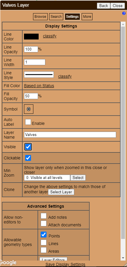
| Display Settings | Change each layer's line color, fill color, symbol, labels, line style, line width, opacity, and visibility. more |
| Custom Schema | Customize the field layout for each layer to include pick lists, checkboxes, text fields, date fields, default values, mandatory fields, etc. video |
| Special Fields | Layers can be configured with special fields to automatically calculate lengths, areas, and coordinates, or record when and by whom an asset was created or last edited. |
| Color Coding | Color code the line and/or fill color of assets based on status, size, condition, last maintenance date, etc. video |
| Arrows | Use the arrow line style to indicate flow direction of gravity lines. |
| Maintenance Tracking | ||
| Attachments | Take pictures or attach videos, pdf's, and other documents to each asset. Documents are uploaded to our server making them accesible to all your users. Attach documents one at a time or we can give you instructions to do batch uploads and linking. |
| Picture Markup | Rotate and Annotate pictures. |
| Record Notes | Maintain a running maintenance history for each asset. Time and author of each note is recorded. |
| Log Sheets | Create a log sheet for select layers so operators can record daily entries from their phone. video |
| Regular Maintenance | Record date of each valve exercise, hydrant flush, inspection, or sewer cleaning and report on which assets are overdue. |
| Work Orders | Create one-time or recurring work orders, assign to specific people, track completion status. video |
| Reporting | ||
| Browse | Browse data in rows and columns with ability to sort, search, and export to Excel. |
| Search | Search any layer for all assets matching simple or advanced search criteria. Browse the results or export to Excel to see totals. |
| Markup | Draw freehand redlining on the map to temporarily markup an area for printing or emailing. |
| Generate large format print files (PDF) that can be sent to a printing company to create wall maps. video | |
| Email Maps | Use the Share button to email an interactive screen shot to anyone even if they are not a user on your account. video |
| Measure | Measure distances and areas. |
| Coordinates | Click anywhere to get Latitude/Longitude coordinates. Or type in coordinates to find a location. |
| Elevations | Click anwhere on the map to see the elevation for that point. |
| Advanced | ||
| Hosting | We use industry leading Amazon Web Services to run our application and store all data on US servers. An AWS server in Canada is used to host our Canadian customers' data to assure that it also stays in-country. |
| API | A .net API is available that allows your vendors or IT staff to programmatically access your data on our server for the purpose of custom reporting or data manipulation. |
| Meter Sync | If your billing software vendor can provide us with a nightly dump of all your customers then we can nightly update your meter layer(s) on your map to reflect the latest names, phone numbers, readings, and other information. We currently interface with Sequoyah, CUSI, and Ampstun. We would love to work with your vendor. |
| Professional Map Makers | Engineering or service companies who manage maps for multiple customers can administer multiple accounts all on one dashboard. more |
$20
per user per month
No Credit Card Required
Billing
We can either invoice you annually and you pay by check. Or you can setup an automatic monthly payment from your credit card, same price either way. You can quit at any time and we will even refund any unused portion of your annual payment.
Support
Have you ever gotten stuck trying to learn something new and wished you could talk to a real person? With Diamond Maps you can call, email, or live-chat one of our US-based map experts to get answers to specific questions, troubleshoot problems, or get suggestions on best-practices.
User Quantity
You can setup a separate user name and password (ie. login) for each user that you purchase.
Each login can be used on any smart phone, tablet, or computer but at only one location at a time. You control which users can make changes to the map.
Unlimited Use Subscription
Also known as the enterprise subscription, this option allows you to give everyone on your staff, including contractors, their own login, all for a fixed price.
For example, a small community that serves a population under 2,000 can get the unlimited-use subscription for less than the cost of two users. Click the chat button for a quote right now 
See frequently asked questions for more details.


Have questions? Want a personal demo? Give us a call. We specialize in working with first time GIS users so all questions are welcome. Or send us your GIS files and we will set you up with a fully working 30 day free trial.
Email
ben@diamondmaps.com
Sales
Support
Office
Brownsburg, IN
United States
DiamondMaps.com is a product of Benjamin A. Hill, Inc.
